Current District Plan maps
District Plan Maps are part of the Waitaki District Plan (Part 5). The maps show the zone of each parcel of land. To learn more please go to current District Plan page.
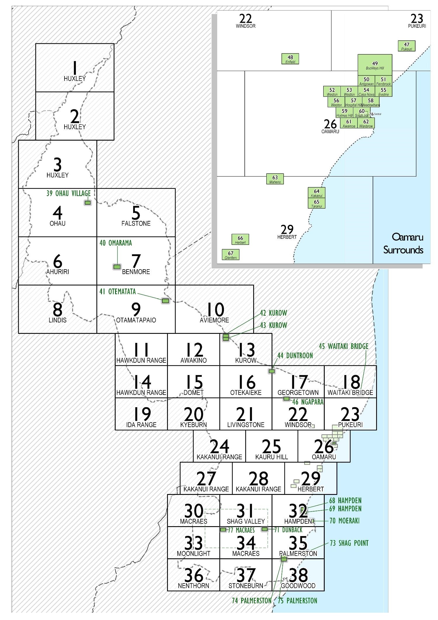
District Plan Index Map

District Plan Maps 1 - 26
- Map 01 HUXLEY - Ahuriri(PDF, 1MB)
- Map 02 HUXLEY - Ahuriri(PDF, 1MB)
- Map 03 HUXLEY - Ahuriri(PDF, 1MB)
- Map 04 OHAU - Ahuriri(PDF, 998KB)
- Map 05 FALSTONE - Ahuriri(PDF, 1MB)
- Map 06 AHURIRI - Ahuriri(PDF, 1MB)
- Map 07 BENMORE - Ahuriri(PDF, 1MB)
- Map 08 LINDIS - Ahuriri(PDF, 1MB)
- Map 09 OTAMATAPAIO - Ahuriri(PDF, 936KB)
- Map 10 AVIEMORE - Ahuriri(PDF, 1MB)
- Map 11 HAWKDUN RANGE - Waitaki(PDF, 792KB)
- Map 12 AWAKINO - Ahuriri(PDF, 741KB)
- Map 13 KUROW - Ahuriri(PDF, 2MB)
- Map 14 HAWKDUN RANGE - Waitaki(PDF, 1MB)
- Map 15 DOMET - Waitaki(PDF, 774KB)
- Map 16 OTEKAIEKE - Ahuriri(PDF, 1MB)
- Map 17 GEORGETOWN - Corriedale(PDF, 2MB)
- Map 18 WAITAKI BRIDGE - Corriedale(PDF, 2MB)
- Map 19 IDA RANGE - Waitaki(PDF, 2MB)
- Map 20 KYEBURN - Waitaki(PDF, 1MB)
- Map 21 LIVINGSTONE - Corriedale(PDF, 947KB)
- Map 22 WINDSOR - Corriedale(PDF, 1MB)
- Map 23 PUKEURI - Corriedale(PDF, 1MB)
- Map 24 KAKANUI RANGE - Waitaki(PDF, 1MB)
- Map 25 KAURU HILL - Corriedale(PDF, 952KB)
- Map 26 OAMARU - Corriedale(PDF, 1MB)
District Plan Maps 27 - 52
- Map 27 KAKANUI RANGE - Waitaki(PDF, 1MB)
- Map 28 KAKANUI RANGE - Waitaki(PDF, 755KB)
- Map 29 HERBERT - Corriedale(PDF, 1MB)
- Map 30 MACRAES - Waihemo(PDF, 2MB)
- Map 31 SHAG VALLEY - Waihemo(PDF, 1009KB)
- Map 32 HAMPDEN - Waihemo(PDF, 980KB)
- Map 33 MOONLIGHT - Waihemo(PDF, 1MB)
- Map 34 MACRAES - Waihemo(PDF, 1MB)
- Map 35 PALMERSTON - Waihemo(PDF, 1MB)
- Map 36 NENTHORN - Waihemo(PDF, 1MB)
- Map 37 STONEBURN- Waihemo(PDF, 1MB)
- Map 38 GOODWOOD - Waihemo(PDF, 1MB)
- Map 39 OHAU VILLAGE - Ahuriri(PDF, 651KB)
- Map 40 OMARAMA - Ahuriri(PDF, 1MB)
- Map 41 OTEMATATA - Ahuriri(PDF, 720KB)
- Map 42 KUROW (Nth) - Ahuriri(PDF, 1021KB)
- Map 43 KUROW (Sth) - Ahuriri(PDF, 1MB)
- Map 44 DUNTROON - Corriedale(PDF, 1MB)
- Map 45 WAITAKI BRIDGE - Corriedale(PDF, 1MB)
- Map 46 NGAPARA - Corriedale(PDF, 841KB)
- Map 47 PUKEURI - Corriedale(PDF, 1MB)
- Map 48 ENFIELD - Corriedale(PDF, 939KB)
- Map 49 BUCKLEYS HILL - Oamaru(PDF, 916KB)
- Map 50 ARDGOWAN - Oamaru(PDF, 752KB)
- Map 51 FERNBROOK - Oamaru(PDF, 1MB)
- Map 52 WESTON - Corriedale(PDF, 870KB)
District Plan Maps 53 - 77
- Map 53 OAMARU - Oamaru(PDF, 559KB)
- Map 54 CASA NOVA - Oamaru(PDF, 906KB)
- Map 55 EVELINE - Oamaru(PDF, 812KB)
- Map 56 WESTON - Corriedale(PDF, 677KB)
- Map 57 HOSPITAL HILL - Oamaru(PDF, 802KB)
- Map 58 MEADOWBANK - Oamaru(PDF, 975KB)
- Map 59 HOLMES HILL - Oamaru(PDF, 993KB)
- Map 60 SOUTH HILL - Oamaru(PDF, 1MB)
- Map 61 AWAMOA - Oamaru(PDF, 879KB)
- Map 62 WANBROW - Oamaru(PDF, 1MB)
- Map 63 MAHENO - Corriedale(PDF, 1MB)
- Map 64 KAKANUI - Corriedale(PDF, 1MB)
- Map 65 TARANUI - Corriedale(PDF, 832KB)
- Map 66 HERBERT - Corriedale(PDF, 854KB)
- Map 67 GLENFERN - Corriedale(PDF, 717KB)
- Map 68 HAMPDEN - Waihemo(PDF, 952KB)
- Map 69 HAMPDEN - Waihemo(PDF, 810KB)
- Map 70 MOERAKI - Waihemo(PDF, 865KB)
- Map 71 DUNBACK - Waihemo(PDF, 797KB)
- Map 72 MACRAES MINING - Macraes(PDF, 1MB)
- Map 73 SHAG POINT - Waihemo(PDF, 860KB)
- Map 74 PALMERSTON - Waihemo(PDF, 1MB)
- Map 75 PALMERSTON - Waihemo(PDF, 935KB)
- Map 76 CENTRAL - Oamaru(PDF, 990KB)
- Map 77 MACRAES - Macraes(PDF, 741KB)
National Policy Statement – Highly Productive Land
Soil maps for LUC classes 1 -3 can be found at: NZLRI Land Use Capability 2021 - Informatics Team | | Environment and Land GIS | LRIS Portal (scinfo.org.nz)
Please note that these are in addition to the mapped High Class Soils in the District Plan and take effect from 17 October 2022.
Canterbury Maps
Canterbury Maps provides a quick and handy way to access our different District planning zones. (To access the maps on the website: Map viewer -> layer list -> District Planning Zones).