Waitaki Weather Updates
Published on 27 July 2022
These updates are now closed.
Update 4.15pm 28/07/22
We still have 29 closures, and 21 roads open under caution. Our contractors are continuing to work hard to open all roads. Find the latest details on our website:
Road work and conditions | Waitaki District Council
Weston-Ngapara Road between Whitstone-Five Forks Rd to Coal Pit Rd will remain closed until Monday due to multiple slips and potentially unstable power poles. There is a detour in place.
And just a note for anyone travelling on roads: There could be road damage because of the flooding. This includes potholes, scouring, minor slips and minor bridge abutment washouts. As we continue to work on a recovery plan, please continue to drive with extreme caution.
If there are any further reports to make, please contact the Waitaki District Council. Call us on 03 433 0300 or 0800 108 081 or service@waitaki.govt.nz. For any emergencies, please call 111.
Update 9.30am 28/07/22
There is no change to our road closed/caution numbers from yesterday at this stage, however it sounds like a lot of the flooded sites in the Corriedale area have receded overnight. We will have further updates later this morning.
There could be road damage as a result of the flooding - this includes potholes, scouring, minor slips and minor bridge abutment washouts. As we continue to work on a recovery plan, please continue to drive with extreme caution.
Update 3.30pm 27/07/22
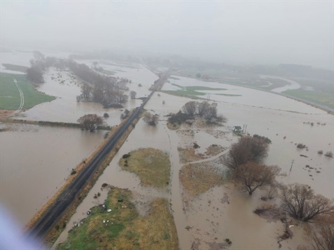
It is still wet out there with areas inland and south of Ōamaru the worst affected. Although the weather has started to ease, continued lower intensity rain means flood waters and river levels will recede slowly. River levels are still being monitored with the larger rivers showing signs of peaking and starting to drop a bit, but smaller rivers are still causing localised flooding.
With over 37 local roads closed due to flooding, slips and trees down, many under caution, and more reports coming in, staff are getting out with signage as quickly as they can and updating the Council website as information comes in. If travel is necessary, take extreme care in weather affected areas as there may be hazards not yet identified and signed out by our crews.
With so many roads affected it is unlikely that they will be safe to reopened before tomorrow morning which will affect school routes and bus runs. Crews will be out reassessing in the morning.
Mayor Gary Kircher says “We thank everyone for their patience and cooperation as the widespread flooding issues continue and we ask that people keep hunkering down and staying off the roads where possible. Our thoughts are with the farmers and rural workers who are looking after livestock in swamped paddocks and challenging conditions during what is an already busy time of year. Our crews are out there doing all we can to look after the current situation and we will be getting our contractors to assess the damage and start the clean-up once conditions improve.”
Water Notices
URGENT CONSERVE WATER NOTICE- WAIHEMO WATER SUPPLIES (PALMERSTON, DUNBACK, GOODWOOD)
Please conserve water if you are a consumer on the Waihemo Water Supply (Palmerston, Dunback, Goodwood). The Shag River is running very high and dirty, and the supply pumps are currently turned off.
If you are a Palmerston resident, please be particularly vigilant about conserving water. This is because most residents don't have storage tanks due to the township having an on-demand supply and we need to make reservoir storage last as long as possible.
Conserving water on these supplies will help us avoid the need to issue a boil water notice in the next day or so.
CONSERVE WATER NOTICE - AREAS OF WESTON SUPPLY
Resident in the Brockmans area (Airedale Road, Brockmans Road, Roseberry Road, Turfus Camp Road, Oamaru Creek Road) of the Oamaru Water Supply's Weston Zone are asked to conserve water until further notice. The map below shows the areas concerned.
There is a significant leak on this part of the network that our contractors won't be able to locate or repair until surface flooding in the area has receded.
As this is a restricted supply, all consumers should have three days of onsite water storage.
CONSERVE WATER NOTICE - AWAMOKO SUPPLY
Consumers on the AWAMOKO Water Supply are advised to CONSERVE WATER until further notice.
The water supply pumps have been turned off due to high flows and dirty water in the Waitaki River
CONSERVE WATER NOTICE - LOWER WAITAKI SUPPLY
Residents on the Lower Waitaki Water Supply (outlined on the map below) are asked to conserve water until further notice. The current weather event has resulted in a high level of turbidity (dirty water) in the supply bores, which have been turned off in the meantime.
As this is a restricted supply, all consumers should have three days' onsite water storage.
Keep an eye on this page and our website for updates.]
CONSERVE WATER NOTICE - TROTTERS GORGE SUPPLY
Consumers on the Trotters Gorge Supply are advised to Conserve Water until further notice.
As a result of the current weather event, there is a leak in the network (likely at one of the river crossings) which is currently not accessible. All going well, this should be repaired tomorrow.
As this is a restricted supply, all consumers should have three days' onsite water storage.
More information and reporting issues:
If there are any further reports to make, please contact the Waitaki District Council. Call us on 03 433 0300 or 0800 108 081 or service@waitaki.govt.nz. For any emergencies, please call 111.
Road work and conditions | Waitaki District Council
Waitaki District Counci Facebook page
Traffic map (nzta.govt.nz)
Metservice Severe Weather Information
Update 10.45am 27/07/22
We have 34 roads and 13 under caution. Our Crews are out on the network inspecting and we’re receiving multiple calls regarding surface flooding and slips.
We have also received reports of parents trying to get their children to school in the Weston/Enfield area as the school buses aren’t operating. Detour routes nearby are also flooded to some degree. The advice to parents is to stay home.
Crews are incredibly busy and getting to hazards as soon as possible. Not all hazards are going to be signed. Please avoid any unnecessary travel.
Update 10.15am 27/07/22
The Otematata and Omarama Transfer Stations will not be opening today due to the operator being unable to get there. Kurow will open. Reports of about 6 inchs of snow near Omarama.
School Updates:
Five Forks School – closed 26/07 pm and all day 27/07/2022 Maheno School – closed 27/07Omarama School – closed 26/07 and 27/07Duntroon School – closed 27/07Ardgowan School - closed 27/07Kakanui School – closed 27/07Totara School – closed 27/07Maheno Kindergarten – closed 27/07Hampden School – closed
Kakanui River:
Kakanui Floodbank at approx 9.30am today - Spillway still operating. Some of Valley Rd flood and probably from side creeks nearer the straight to Whatons Rd. Not much sign at all of over topping currently.
Excerpts from Media Release from Emergency Management Otago:
Rain continues to fall across Otago
MetService have extended the heavy rain warning until 3.00pm today with North Otago and Dunedin expecting a further 15 -20mm in addition to what has already fallen. Accumulated amounts reached up to 140mm across Dunedin and 120mm in North Otago in the previous 24 hours.
Emergency Management Otago is advising people to take extra care when out and about today.
State highway 1 Dunedin to Palmerston remains closed and SH1 Maheno is open with speed restrictions and a number of local roads in Waitaki are closed or on restrictions. Some local roads in Waitaki, Clutha and Dunedin remain closed, and people are advised to check their Council website for updates.
Orbus Dunedin's route 1 bus service (to/from Palmerston) has been suspended and updates will be posted on Orbus Dunedin facebook page and the below schools are currently closed, parents should be in contact with their schools to find out when they reopen.
- Five Forks School
- Maheno School
- Omarama School
- Duntroon School
- Ardgowan School
- Kakanui School
- Totara School
- Maheno Kindergarten
- East Taieri Preschool
- Hampden School
Otago Regional Council engineering staff continue to monitor vulnerable rivers and streams and the Shag, Kakanui and Taieri rivers still remain high and the Leith will continue to rise over the next few hours with the Henley spillway predicated to operate later this morning.
Group Controller, Matt Alley said” We believe the worst of this weather event is behind us however we are maintaining a watchful eye throughout the rest of the day. People should continue check Facebook pages, websites and Waka Kotahi for updates on state highway and local road conditions”.
ENDS
Update 8.45am 27/07/22
North Otago: Rainfall is expected to ease by late morning. Kakanui river has remained at high levels overnight. At Clifton Falls has peaked early this morning, and now appears to be nearing a peak at Mill Dam The Shag has recently peaked at the Grange, and is still rising at Craig Road.
Dunedin: Rainfall is expected to ease by late morning, but localised higher intensity falls continue. Leith and Lindsay have remained at high levels overnight with multiple flow peaks occurring. The Leith is currently rising again, and may exceed last night’s highest peak of ~67 cumecs.
Taieri: Rainfall at Swampy spur has eased, and Silver Stream is receding. The Taieri at Outram is rising and currently at ~470 cumecs. This is above 2nd alarm level but is not expected to each 3rd alarm level of 725 cumecs. The Henley spillway is expected to operate at about 10-11am.
Lower Clutha: The Tokomairiro and Pomahaka rivers have risen, but now have peaked or appear to be near flow peaks. The Tokomairiro reached its 1st alarm level of 26 cuemcs, peaking at 40 cumecs.
Latest Metservice -Area: North Otago Valid: 6 hours from 8:00 am to 2:00 pm Wednesday Forecast: Expect a further 15 to 20 mm of rain. Peak rates of about 10 mm per hour. This is in addition to the approximately 80 to 120 mm of rain that has accumulated in the last 24 hours. Note that a couple of stations are reporting more than 160 mm during that period.
Update 6.45am 27/0722
Kakanui at Mill Dam 299 cumecs and although plateauing earlier is now rising again. Shag at Craig Road 251 cumecs and rising still. Shag at the Grange also rising. Others look to be dropping. ECAN report Canterbury part of the Waitaki District. Precipitation has mostly fallen as snow in the recently flooded catchments in this region. No significant river rises have occurred and no significant river flooding problems are anticipated.
Overnight reports were made of flood conditions are causing hazards across the network. We have had staff working through the night, if travel is necessary take extreme care is recommended in weather affected areas as there may be hazards not yet identified and signed out by our crews.
For up to date closure information please refer to the Waka Kotahi Journey Planner: journeys.nzta.govt.nz/
For local roading conditions check: Road work and conditions | Waitaki District Council
Update 6.30pm 26/07/22
Rainfall accumulations for North Otago are still showing higher observed rainfall amounts and intensities in some areas than was forecast yesterday and this morning. Expect to see heavy rain over night. Metservice are predicting rainfall accumulation over this period for the North Otago of approximately 60-90mm additional to the 30-40mm that has already fallen, with peak intensities between 10-15mm. Gradually easing into the morning.
Kakanui River is rising and will continue to rise during the night. Flooding is likely to farmland near the river, the bowling club in Maheno might be inundated. Flow estimation indicates that flooding of SH1 around Mill Dam is expected later tonight.
Kauru River is likely to flood the area near Gemmels Crossing.
Shag river catchment: flooding of low-lying land beside the river is likely.
Update 5pm 26/07/22
We have received more inclement weather across the day, and this is forecast to continue overnight. We are preparing for more road closures and flooding.
Rivers and streams:
We continue to monitor river levels with the Kakanui River as our current priority. Other rivers and waterways remain manageable but are rising.
We ask the public to continue to keep away from any waterways as rivers and streams may change. Unless you are a resident, we request people stay away from damaged areas. Your presence might put you at further risk from the residual effects of floods, such as contaminated water, damaged roads, and other hazards.
Roads and flooding:
Over 20 roads are currently closed and several more are on caution. This will continue to be updated, with more expected closures overnight.
Schools have been advised that any roads that are currently closed will not be open in time for the school run tomorrow morning. There will also be further road closures overnight.
For local snow affected roads, we do not carry out snow clearance until 24 hours after the last snowfall and there is no snowfall predicted for 48 hours. Rain and freezing after a snowfall can create ice and further hazards.
Please follow any signage and road cones and do not remove or alter temporary road signage. This can create a hazard for other road users and is also a criminal offence. Do not remove or adjust any signage or cones.
SH1:
- Maheno - Road is likely to close due flooding across SH1 at Maheno
- Waikouaiti River, Waikouaiti- open, rising water, risk of flooding across SH1 being monitored
- Big Kuri Creek, Hampden – likely to close, rising water, risk of flooding across SH1 being monitored
SH85:
- Shag River, Waynes- open, rising water, risk of flooding across SH1 being monitored
The A2O is currently closed, and the conserve water notice remains in place for the Windsor water supply.
Otago Regional Council update: 5pm 26 July
Emergency Management Otago is asking people and residents in their homes to remain vigilant of water levels in their area overnight, particularly in areas more susceptible to flooding, as heavy rain continues into the evening across Otago.
Otago Regional Council engineering staff are positioned at vulnerable rivers and streams overnight – the list of rivers is available on the top of the Otago Regional Council’s website https://www.orc.govt.nz/managing-our-environment/water/water-monitoring-and-alerts#MonitoringSites.
Council staff from Clutha, Waitaki, and Dunedin City along with emergency services and lifeline agencies are closely watching and preparing as the evening unfolds. People are advised to dial 111 if there is an emergency and should keep contact details of their district or city councils on hand.
Emergency Management Otago, Group Controller Matt Alley asked people to check their Council websites, Waka Kotahi NZ Transport Agency and Facebook pages for updates.
Residents should continue to observe any water notices and to ensure their household plan, emergency supplies including stored water and getaway kits are prepared.
Update 3pm 26/07/22
A reminder to stay away from rapidly rising rivers and streams. Prepare for high flows and keep away from low lying flood prone areas.
SH1:
- Maheno - Due to flooding across SH1 at Maheno there are temporary speed restrictions in place. Road users are advised to take extreme care.
- Waikouaiti River, Waikouaiti- open, rising water, risk of flooding across SH1 being monitored
- Big Kuri Creek, Hampden – open, rising water, risk of flooding across SH1 being monitored
SH85:
- Shag River, Waynes- open, rising water, risk of flooding across SH1 being monitored
Environment Canterbury Update:
Last updated: 2.11pm Tue, 26 Jul 2022: Rain has been falling across the region since yesterday afternoon, and forecast to persist in southern areas into tomorrow morning. Current information for each district is provided below.
Canterbury part of the Waitaki District Precipitation has mostly fallen as snow in the recently flooded catchments in this region. No significant river rises have occurred so far and no issues relating to large rivers reported. As this event continues into Tuesday evening/night some of the areas receiving snow may change to rain and situations in saturated, recently flooded catchments should be monitored.
Mackenzie District Precipitation has mostly fallen as snow in the recently flooded catchments in this region. No significant river rises have occurred so far and no issues relating to large rivers reported. As this event continues into Tuesday evening/night some of the areas receiving snow may change to rain and situations in saturated, recently flooded catchments should be monitored.
Waimate District The Lower Waitaki River flows may increase due to inflows from tributaries below the Waitaki Dam but spill flows from the dam itself are not anticipated. Foothills rivers and smaller coastal catchments throughout the district are rising. As at 1pm Tuesday the Pareora (160 cumecs), Hook (25 cumecs), Otaio, Makikihi and Waihao (200 cumecs) Rivers have all risen sharply but apart from localised flooding into low-lying areas no issues have been reported. Expect these rivers to continue to rise through the rest of Tuesday and into Wednesday morning and adjacent landowners should closely monitor their own situations and take action where necessary.In the Hakataramea, the precipitation has fallen as snow in the upper part of the catchment limiting flows.